This just in on my MSN newsfeed:
“A magnitude-5.6 earthquake has hit the West Australian town of Manjimup, about 300 kilometres south-west of Perth, with tremors felt as far away as Perth and Albany.
The earthquake happened about 1:00pm (WST). There were no reports of damage.
The Bureau of Meteorology WA said there was no tsunami risk to Australia. It said the quake was centred near Lake Muir and forecasters working in its West Perth headquarters felt the building sway.
Dardanup resident Jill Cross said she was watching TV when she felt her house shaking.
“I thought ‘am I having a bit of a giddy turn or something?’,” she said.
“The ceiling fans and the light fittings were all swaying. It only lasted for a second or so but enough where you felt ‘what’s going on here?’.”
More to come.
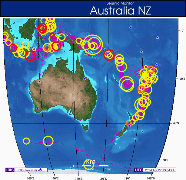
And checking out the Iris seismic Monitor…

As you can see this is WELL off the beaten path for regular seismic activity! What’s going on here?
Check this out! This from a Colin Andrews blog eight years ago:
http://www.colinandrews.net/2012-EarthChanges-QuakeWesternAustralia.html
A rare Earthquake hits Australia. Does this place look familiar?
Is a picture emerging?
Earth Changes Special Report:
Colin Andrews
April 20, 2010
At 00:17 UTC today a rare Earthquake of 5.3 slammed an area 29 km North East of
Kalgoorlie-Boulder, Western Australia. Does the location look familiar?


It should if you have been following the unexplained strange symbols appearing on
Australian weather radar since January 15th just over three months ago. The first
strange ring reported to me and that started my research was near Kalgoorlie-
Boulder in West Australia, at the same location as today’s Earthquake.
Today’s rare quake does raise the obvious question: Is it part of the radar story or
is it ‘The’ story? And of course they may be totally unconnected.
After three months research into the radar symbols (called by Australian Media
‘Digital-age Equivalent to crop circles’)The Bureau of Meteorology who own and run
most of the radar stations could only say that the mysterious patterns were
unexplained interferences and that they were trying to resolve ‘the problem’.
It might be noteworthy that the most extraordinary of the patterns that followed,
appeared on the east coast which overlooks what has also become a very active
seismic area. Reports received just yesterday that authorities are preparing to
evacuate thousands as Volcano Gaua becomes dangerous to the NE of Australia,
out in the Pacific Ocean.
Again, so little is known about the cause of the radar ‘interference signals’ or the
now obvious dramatic increase in Earth changes that one can only make intelligent
but informed speculations. We should look at all the data and not be afraid to think
outside the box. Are these changes a result of Solar activity or is the sun itself
being influenced by something greater in the Galaxy or even beyond?
Could the source of the dramatic changes be created much closer to home? Many
top level scientists, some of them whistle blowers and even high level politicians
who got a sniff of the military industrial complex, believe these folks would do what
ever it takes to create weapons to achieve their dark agenda’s. My personal
observations of recent years on this planet permits me to believe this might be
true. They are prepared to lie us into conflicts we can see and touch are
unnecessary and manufactured and I doubt very much they would stop at using
nature herself if they could get it to work for them. Turning on a logistically placed
Volcano or two or turning off a weather system or two could well be the new
weapons of choice. That is a nightmare thought I know and not one that I wish to
focus but we have to be real. Some folks among us are evil.
The initiating radar symbol over Western Australia seemed to be the trigger for a
whole series of them and in various forms. Perhaps co-incidentally today’s quake
comes ahead of a multitude of medium size quakes also in six countries.
Ruby red burst seen on BoM national radar along the
East coast facing active volcano Guau. Alerts now in
force. (Note also Fuji quake today)
The Kalgoorlie-Boulder radar symbol triggered a whole series
over the continent. Copyright: Colin Andrews.
The Kalgoorlie-Boulder Earthquake in Australia came ahead of a
whole series which struck the South Sandwich Islands Region,
Mexico, Pakistan, Chile and Fiji.”


